

It’s been a wonderful few weeks as we made our way through the South while heading towards Colorado where we intend to spend a few weeks in several different campgrounds in the Rockies and spend some time with my son Morgan and his girlfriend Ashleigh. The time spent thus far coming up and out of the south from Arkansas, Oklahoma and into Kansas can be described as both memorable and adventurous.
We came out of the Natural State of Arkansas from the western border and drove across the entire state of Oklahoma, or so it seemed. Our route took us through the center of the state by way of Tulsa and Oklahoma City with an overnight stay in Woodward, OK. The winds on this part of the journey were epic with 30-45 mph sustained and up to 65 mph wind gusts. It was a real struggle to say the least to drive Big Lewie through these conditions, testing my newfound RV driving skills accompanied with a white-knuckle grip, clenched teeth, and adrenaline on high. The town of Woodward would be our overnight destination, and was a welcome one as the winds only seemed to get worse the closer we got. Just in our RV park alone, the wind managed to topple a few small trees and scatter many resident’s personal belongings and garbage across the area. Woodward, OK is a small blue-collar farming and energy town with deep American Indian history that would only be a brief respite for us before heading deep into the panhandle of Oklahoma towards the very remote Black Mesa State Park.
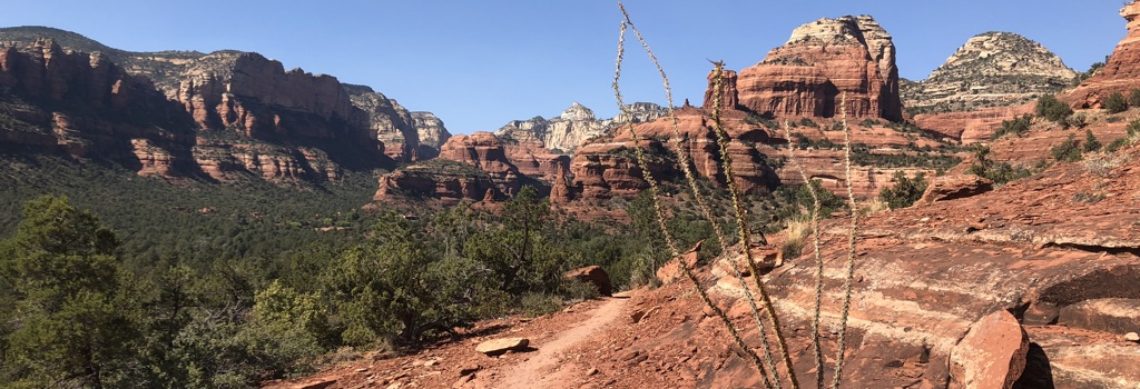
There is a lot of open space in Oklahoma. Miles and miles of farm country at times that seemed to go on forever. The OK landscape does take a turn as you get into the panhandle, becoming more desert like, with picturesque mesas rising out of the ground to greet the sky. I would describe the OK landscape as uniquely beautiful in its own rite but also quite inhospitable with its arid climate, minimal opportunity for shade, and maximum opportunity for sun exposure. Little did we know that after we went through Boise City, we would be over 30 miles from civilization with no gas stops, internet, cell signal, or grocery store. While a bit of an uneasy feeling being that disconnected and remote, there was also something peaceful and very liberating about it. Not being beholden to a cell phone is something I have dreamt about for years and this would be just one of what I would hope to be many opportunities to enjoy and appreciate having this chance.
One of the upsides to being so remote is the ability to really enjoy the nighttime sky. The Black Mesa State Park advocates for a true lights out experience for its campers, with almost no night time illumination anywhere in the park. This of course lends itself well to seeing an amazing nighttime sky, given the proper cloud cover, which certainly did not disappoint during our stay.
The high point of OK is called Black Mesa and would only be a few miles from where we were staying in a nature preserve down the road. The realization of just how isolated we were sunk in even further as we drove the 15 or so miles into the desert in search of the trail head that would ultimately take us to the top of Oklahoma. Along the way we passed what appeared to be something straight out of Hollywood, or an almost manufactured ghost town of sorts, as if it were being prepped for an upcoming Clint Eastwood spaghetti western.

Weather conditions were ripe for us to make the 8-mile round trip to the summit. Temps were in the low 50s with a light wind out of the south. Jax and Henry were in tow as we made our way happily across a mostly flat trek with a brief incline for a few hundred feet before reaching the top of the mesa. Once on top of the mesa, we had about a mile stretch of open tundra before finally seeing the obelisk monument marking the state high point.

The time spent in the OK panhandle was pleasant and a quite enjoyable experience however, we were ready to be on our way to Kansas to quickly conquer its high point, and then ultimately get our Rocky Mountain high on in Colorado.
Southeastern Colorado’s landscape resembles Oklahoma in many ways with its endless miles of open views and with little sign of anything man made. The thought of breaking down and requiring emergency service did cross my mind a few times, conjuring up multiple sequences of what we might do if any one scenario played out and how we might handle it. The RV gods continue to smile upon us however, as we made our way out of the OK panhandle from the south and into southeastern Colorado’s farm country heading towards Mt. Sunflower Kansas. Sunflower is the state highpoint and it sits on the border of Kansas and Colorado, just north of Weskan, KS by about 15 miles. It is literally the highest prairie around and one of the more neatly decorated high points we’d been to thus far. Decorated with some real Kansas flare, the high point was reminiscent of a shrine riddled with sunflowers and other items considered to be native to the great state of Kansas. Hard to believe it sits just above 4000 ft when you’re standing there looking around and all you can see is windmills in any one direction.

Our long day on the road came to a close in Cheyenne Wells, CO alongside a Cargill grain “elevator.” Kind of an odd place you might think for a campsite, but a very convenient and welcome one we were able to find in a pinch which would be in proximity to the CO/KS border and only three hours from Colorado Springs, our next destination.

You have officially solved the mystery! Awesome to read about your adventures!
Glad you are enjoying our journey. What mystery was solved?